For most of this stage of this part of our journey we were joined by my brother, Clive. He arrived in
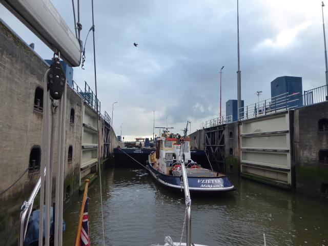
Tonning on another sunny day and found the town as attractive as we had. The next morning we were sufficiently afloat to be able to leave just after 2 hours before HW and so we cautiously made our way out into the River Eider on a sunny morning with light wind. As we headed W about 7nm to the last lock, the Eider-Sperrwerk, we followed a well buoyed channel seeing plenty of bird life on the slowly submerging sands and banks. The Eider-Sperrwerk is a lock which is part of the major flood defence scheme that can, when needed, control the flow in and out of the Eider.
 |
| Through the Eider-Sperrwerk |
 |
| Tonning to Texel in orange |
After the lock for the next hour we followed a buoyed channel to the safe water buoy by which we were half the 42nm to
Helgoland. This is essentially a settlement on red rocks with an adjacent sandy island. Although part of Germany it is outside the EU and Germans therefore head there in their numbers to buy duty free alcohol and tobacco. The mooring arrangements are inadequate and less than satisfactory so that when we arrived at about 1830 we were the fifth boat out from the pontoon on a raft of sailing boats. Apparently in high season boats raft ten out! Once secured we were greeted with the news that the inside boat was leaving at 0530! So up again a little before whilst the rest of us cast off, milled around the harbour and then re-secured. Other rafts similarly moved around in the following hours. We decided that we would leave with the tide at about 1000. We had a quick look around the mainly featureless town. This was not a surprise as over the years Helgoland has often been fought over. Indeed at one stage it was British but around 1900 it was swapped in a deal with Germany for Zanzibar! The island was evacuated in WW2 and the RAF were said to have used it for bombing practise!
 |
| Plenty of small hotels |
 |
| 1950's and 60's buildings predominate |
 |
| Most vehicles are electric |
We left Helgoland and had a stronger than expected S F5/6 wind and some rough seas for the first couple of hours. We were heading SSW initially to skirt around the shipping lanes off the rivers Elbe and Jade before turning W to pass along the East Frisian islands. We arrived in
Nordeney on a summer's evening just after 1900 having completed 49nm. We visited Nordeney in 2016 and liked this smart and stylish spa and holiday island. We had an enjoyable and very warm day around the town and then walking for some miles through the dunes and along on the coast.
 |
| Classic Victorian architecture |
 |
| The Conversation Hus (a cafe) |
 |
| The lighthouse |
 |
| Outside the town miles of dunes |
 |
| Plenty of sand between the S of the island and the mainland at LW |
Our next island destination was
Borkum a little over 30nm W. Another sunny day with very light winds so we had to motor sail. There are two harbours on the S side and we had to fight the falling tide as we rounded the W of the island. It was about LW-2 and I had calculated that we should have had enough water to get into Port Henry, the yacht harbour. But a little way up the narrow entrance channel we touched the ground so we beat a hasty retreat and went to the mainly commercial harbour next door. There is a small craft marina from which we could observe at close quarters plenty of commercial activity, mainly wind farm servicing ships but also the pilot cutters and ferries. The harbours at Borkum are 7km from the town but there is a railway that runs from the ferry to the town so we made use of that. It was Sunday and there were plenty of holidaymakers in what is an attractive and popular town.
 |
| Borkum from the lighthouse |
 |
| Strandkorbs on the beach |
 |
| Kite surfing, wind surfing and sand yachts all enjoyed |
 |
| Some attractive properties |
 |
| An old diesel train, current stock to the left |
 |
| Was a running afternoon for the historic steam (oil fired) engine |
We now had a choice to make as our plan was to continue SW along the North Sea to the Dutch West Frisian islands. This would involve a passage if around 75nm with perhaps anchoring half way for one night. However the forecast for Monday was for strong W winds and then for Tuesday to Thursday SW gales. So we had plan B!
On Monday morning we headed S down the River Ems in a brisk F4 making rapid time with wind on the beam and the River flooding. By noon we were in the first port of the Netherlands, Delfzijl and waiting to enter the lock that would take us into the North Frisian Canal. This is a part of the Staande Masteroute with bridges that can lift. We made good progress along the first part of the canal, seven bridges lifting relatively quickly and so by 1530 (after 39nm) we were in the university town of
Groningen, the provincial capital. We have been along this part of the route before and think that Groningen is an attractive and vibrant city.
A feature of Groningen is the significant number of bridges that you have to pass under. Some of these are grouped so that a Bridge Master has to cover two or three, cycling between them. So you have to wait between bridges for him or her to do that.
 |
| University building, many students around |
 |
| Numerous bikes, biggest risk to pedestrian safety! |
 |
| The town is surrounded by a ring of canals with many historic ships |
 |
| Attractive buildings |
 |
| Art noveau style | | |
 |
| Waiting for a pedestrian bridge |
 |
| Following a yacht through the city |
The Tuesday that we left was wet as well as windy and with some repairs to the fresh water system required initially, coupled with the slow progress through the town and a stop for refuelling it was nearly 1900 when we reached
Zoutkamp. Just 19nm but one lock and 19 bridges to lift.
Zoutkamp was originally a fishing village in the North Sea. Now that access is through locks and a dam has enabled land to be reclaimed. But Zoutkamp still has its fishing fleet and fish and shrimp processing plants.
 |
| An overcast day in the harbour |
 |
| New buildings on the quay |
 |
| The harbour with a little sun, Whileaway on the left |
The next morning was again very showery with strong winds. As we headed away a fishing boat was returning to Zoutkamp. Our next stop was to be
Dokkum, just 15 nm away. But en route we passed through open water and the Slenk and Lauwersmeer before rejoining the narrower canal. The very strong wind was particularly noticeable here.
Dokkum was originally a port built on a group of terpen and was the HQ of the Frisian Admiralty until the approaches silted up in the 18th century. The town was very busy as a festival was taking place the following weekend. It is another picturesque and moated town with canals surrounding it. Again we have spent time here before.
 |
| Fishing boat in the channel |
 |
| Typical Dokkum street |
 |
| Pleasant setting |
 |
| Ex-RNLI lifeboat! |
We left our mooring in Dokkum on Thursday 5 September and joined a big Dutch barge and another sailing boat as we passed under three lifting bridges. At the second of these bridges we had the relatively rare obligation to pay Bruggeld, a toll for the bridges. There are only a few places that charge this and Dokkum is one of them. There is a notice saying that the charge was €5 (for passing through all the bridges). As boats slowly pass under the bascule bridge the Bridge Master lowers a clog on a string connected to a fishing rod and your fee is placed in it.
 |
| Approaching one of the two mills on the canal in Dokkum |
 |
| Dutch barge and yacht keeping us company. |
After Dokkum we only had a few bridges to cope with before Leeuwarden. However a bigger challenge was the fierce cross wind, mainly F5/6 but touching 30 kn (F8) at times.
We decided to stop at lunch time at the attractive city of
Leeuwarden, the capital of Friesland. Here it is easy to moor alongside the canal in their central park. This is another university city with an extensive town centre, including superb cheese and smoked and dried sausage shops opposite each other.
 |
| The Waag Hus (16th century) where cheeses used to be sold |
 |
| Notable buildings |
 |
| The Princesshof (18th century Town Hall) |
 |
| Children entertaining themselves! |
After Leeuwarden the main canal splits, the main branch heading SW towards Lemmer whereas we continued W towards
Harlingen on the Van Harinaxmakanaal. To begin with this is very much in open country but as you near Harlingen many more commercial uses and traffic became evident.These included sand and gravel and other construction facilities as well as small shipyards and repair facilities.
 |
| One of the shipyards |
Just before the main sea lock at Harlingen we turned to port and entered the small sailing club harbour. Harlingen is a significant sea port with picturesque houses and warehouses. It has a very large fleet of Traditional Dutch barges most built in the early 1900's. The Saturday we were there was very overcast, windy and wet but there was plenty to see. We were particularly interested in the Willem Barentz, a reconstruction of a 16th century sailing ship in which Barentz led an expedition to find the North West Passage in 1596-7. Only 12 sailors escaped and survived after the shop was trapped in the ice for the winter and then sunk. It is hoped that the reconstruction will be ready to sail in 2020.
 |
| Barge negotiating the entrance to one of the inner harbours |
 |
| And another ... |
 |
| The Willem Barentz |
 |
| Masts being shaped |
 |
| Ships Captains and merchants houses |
 |
| One of the four lions on a bridge |
 |
| Painting on a house wall |
On a brighter Sunday morning we entered the commercial lock at Tsjerk Hiddessluizen and were followed in by a barge that was only inches narrower than the lock! Impressive manoeuvring by two tugs. We then headed back to sea following channels between drying sands. The weather brightened up and we passed dozens of Dutch barges tacking up and down in the Waddenzee.
 |
| Inside the lock with the tug and barge |
 |
| Small barge tacking across the channel |
 |
| A great sight |
We headed N to the rural West Frisian island of
Vlieland, a distance of 19 nm. We had the tide with us until we had to round a big sandy island to reach the harbour near our destination. Vlieland has very little motorised transport being mainly a bikers and hikers island. So naturally we got our bikes out for a cycle around. This included visiting the lighthouse on one of the few hills on the island and cycling down the coast seeing bird life, horses, cattle etc. We also read about HMS Lutine, one of many ships wrecked on the sands around this coast. The Lutine was wrecked in a storm in 1799 whilst carrying a large shipment of gold, which because of the shifting sands the majority has never been recovered. We have seen the Lutine Bell because it was recovered and handed to Lloyds Register of Shipping where it became a tradition to ring it whenever there was a significant shipping loss.
 |
| Ferry dock in the foreground, harbour in the background |
 |
| The fast ferry to Harlingen |
 |
| The lighthouse |
 |
| Plaque inside the lighthouse |
 |
| The main street |
 |
| Goat sculpture marking street improvements |
 |
| Canon from the Lutine |
 |
| The south shore |
From Vlieland we sailed carefully through channels between drying sand banks to the larger neighbouring island of
Terschelling. Here again there was reference to HMS Lutine and a map of the shifting sands and the navigational marks on the islands suggesting that the crew may have confused marks on Terschelling for those on Vlieland leading to the wreck. In the harbour was an art work created a few years ago which enables you to see the depths in the various channels at the current state of the tide. A big lever rests in the water and as it moves up and down the locations are either above or below water. Here again we biked some distance (about 30km) around the island on a lovely sunny day.
 |
| Main street in Terschelling |
 |
| Many items recovered from wrecks and the seas |
 |
| Clever art work showing tide heights |
 |
| Memorial to HMS Lutine suggesting a navigational error |
 |
| Looking back to the town at LW |
 |
| Plenty of sand at LW |
 |
| Spoonbills searching for food |
 |
| Traditionally ploughing a very small field |
 |
| Flags of Netherlands and Terschelling |
Our final West Frisian island stop was the largest,
Texel. Clive left us at Terschelling to catch the ferry back to Harlingen and we set off with the tide and headed SW before rounding the island to reach the harbour at Oodeschild after 41nm.
 |
| Gulls chasing the fishing boat off Texel |
The next day was a gale with heavy rain. It was F6 gusting F8 and the boat was certainly rocking in the harbour. We went out for lunch and were drenched! So we stayed an additional day, thankfully the weather improving.
Texel is, of course, known for its sheep breed and many were in evidence as we cycled round. Apart from grazing the dikes and levees sheep also graze the fields. In many cases the boundaries are small turf walls, presumably also providing protection against the wind.
The main shipping and leisure harbour is in Oudeschild. In the village is a windmill with aluminium sails. It was bought here in the 1950's as a trial project to generate electricity from wind power which it did for many years. When it was passed in capacity by modern wind turbines it fell into disuse but has since been regenerated by a charitable trust.
Near Oudeschild we came across a Georgian war cemetery with over 400 bodies. These were men conscripted into the German army as an alternative to going to a prison camp. They rebelled on 5/6 April 1945, killed many Germans but then reinforcements arrived from the mainland. A fascinating story is outlined in Wikepedia under "Georgian uprising on Texel". It may also explain why the town centres that we saw didn't have so many older buildings as other places in the Netherlands.
 |
| Field of sheep with turf wall boundary |
 |
| Windmill in Oudeschild |
 |
| Church in Den Hoorn, partly from 1425, tower used as lighthouse historically |
 |
| Oldest house in Texel built 16th century |
 |
| Typical N coast beach, backed by dunes along its length |
 |
| Tuk Tuks for hire |
 |
| Centre of Den Burg, the largest town |
So we have completed our cruise along the Frisian islands. Even now in Texel we have strong W winds again so no surprise that we had to use the canal in part. But we really like the towns there anyway so no hardship. Tomorrow we hope to enter the Ijsselmeer for our final 10 days on this trip.


No comments:
Post a Comment